


The Ganga Expressway is one of the most ambitious projects in the field of infrastructure in India as the project is set to transform the way people connect in Uttar Pradesh. The mega expressway, which measures an incredible 594 kilometers, will link the western industrialized state of Meerut with the culturally important city of Prayagraj that is located in the eastern part of UP. The Ganga Expressway is a revolutionary development in the Indian road network since construction is at 84% at the end of June 2025.
This greenfield expressway does not promise to save time on the road, but it is designed to increase economic growth and provide better defense opportunities due to its exclusive IAF airstrip and development prospects never seen before in 12 districts. With the final completion of the longest expressway in the UAE, UP, which is scheduled to take place in February 2026, it will transform the logistics, tourism, and urban development in the region.
What Is Ganga Expressway? (Project Overview)
The Ganga Expressway is a state-of the-art, access-controlled expressway that is intended to reduce the time taken between the western and eastern Uttar Pradesh to more than 12 hours to only 8 hours. The project is officially called the Ganga Expressway Project and it is a 594 kilometre marvel that links Bijauli village in the Meerut district and Judapur Dandu in the Prayagraj district.
At an exorbitant ₹37,350 crores the expressway boasts of the state-of-the-art infrastructure with a massive 12-lane bridge spanning Ganga river and awe-inspiring 3.5 km of emergency airstrip that allows the use of the Indian Air Force aircrafts – the first on any Indian expressway.
Executing Authority:
- Uttar Pradesh Expressways Industrial Development Authority (UPEIDA).
- Government of Uttar Pradesh
- Indians support the National Highways Authority (NHAI).
Importance for Logistics, Defense & Regional Development:
- Strategic defense facility of operational IAF emergency landing facility.
- Secondary transportation link between western industrial/UP and east agricultural areas.
- Big improvement in the rise of the regional GDP by building industrial corridors.
- Improved religious tourist connections (Kumbh Mela).
Expressway Features:
- 6 lane (8 laneable) arrangement.
- Design speed: 120 km/h for cars
- 1,500 buildings such as bridges, flyovers and under passes.
- 9 contemporary complexes of amenities with food courts.
- State-of-the-art CCTV surveillance and emergency response.
Toll Rates for Vehicles (FY 2025-26):
- Cars/Jeeps/Vans: ₹2.55 per km
- Light Commercial Vehicles: ₹4.25 per km
- Standard Trucks: ₹8.15 per km
- Oversized Trucks: ₹16.05 per km
Permitted Vehicles:
- Four-wheelers and above only
- Two-wheeler and three-wheelers are banned.
- Business and personal cars permitted.
- Farming equipment on selected service roads.
Construction Status & Deadline
As of June 2025, Ganga Expressway construction has recorded an impressive development of 84% completion which is a credible effort by UPEIDA in terms of deadline-observance. The earthwork is already 99% complete with some of the important layers such as Granular Sub Base (95%), Wet Mix Macadam (94%), and Dense Bituminous Macadam (92%) being at an advanced stage.
The structural project is a masterpiece with 1,476 structures out of 1,500 scheduled structures already being in place such as the magnificent 960 meter Ganga bridge. The rest of the work is mainly on the installations of the toll plazas, signage systems and final surface treatment to prepare the expressway to its expected opening in the year 2026 .
Why It Is One of India’s Most Important Greenfield Expressways:
- Uttar Pradesh has the longest expressway in India with a length of 594km.
- First expressway incorporating the IAF emergency airstrip (3.5 km)
- Tie 12 major districts in building economic corridors never seen before.
- Defense and national security strategic value.
- Ganga river 12-lane crossing- engineering wonder.
- Toll rates pre-determined with financial transparency.
Ganga Expressway Route Map (Complete Overview)
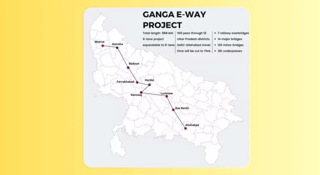
The route of the Ganga Expressway has been carefully designed to pass through the geographical variation of Uttar Pradesh with large parts gently adjacent to the sacred Ganga river. Beginning in the Meerut district at Bijauli it proceeds eastwards along the industrial centre of western UP, across the agriculturally productive central plains, and ends at Judapur Dandu in Prayagraj.
The route is a strategic link between major economic hubs and serves areas that were not served before. The alignment of the expressway has integrated 12 districts, which will balance the development of the regions in western, central, and eastern Uttar Pradesh, which will form a smooth transportation line that will significantly transform the economic geography of the state.
Ganga Expressway Route Map – District Wise
| District | Region | Key Connection Points | Approx. Distance from Start |
| Meerut | Western UP | Bijauli (Starting Point) | 0 km |
| Hapur | Western UP | Delhi-Meerut Corridor Link | 35 km |
| Bulandshahr | Western UP | Industrial Zone | 85 km |
| Amroha | Western UP | Historic City Center | 140 km |
| Sambhal | Western UP | Handicrafts Hub | 180 km |
| Budaun | Central UP | Agricultural Trading Center | 240 km |
| Shahjahanpur | Central UP | IAF Airstrip Location | 330 km |
| Hardoi | Central UP | Mid-route Connectivity | 420 km |
| Farrukhabad | Central UP | Ganga River Crossing | 470 km |
| Kannauj | Central UP | Perfume City Link | 500 km |
| Kanpur Nagar/Dehat | Central UP | Industrial Corridor | 540 km |
| Prayagraj | Eastern UP | Judapur Dandu (End Point) | 594 km |
Districts Covered by Ganga Expressway
Meerut
As the western entry point to the Ganga Expressway, the Meerut district is the starting point, at the village of Bijauli. This industrial giant has the advantage of improved connectivity to the Delhi-NCR area as well as having direct access to the eastern markets. This is because the entry point of the expressway in Meerut will spur industrial growth, invite logistical hubs and dramatically increase real estate prices in the residential neighborhoods around it making it a key transportation centre.
Hapur
The strategic value of Hapur district is that the expressway crosses with the Delhi-Meerut corridor forming a point of strategic importance to the traffic in the region. Such connectivity allows smooth transit of NCR to eastern UP and makes Hapur a possible logistics and warehousing center. The agricultural produce markets in the district will have better access to the wider consumer markets and new industrial opportunities will arise along the expressway path.
Bulandshahr
Bulandshahr is a prime point on the Ganga Expressway, a place that is about 85 kilometers to Meerut. The district is famous in pottery industry as well as agriculture and with enhanced access to the market; it is going to change its economy significantly. The expressway will help unleash the industrial potential of Bulandshahr and attract manufacturing investments and generate thousands of jobs and lower transportation costs to the local business.
Amroha
Modern connectivity in the Ganga Expressway gives the historic city of Amroha that is known as the city of musical instruments and cultural heritage. Amroha lies in the western part of the UP and the traditional industries of the area such as musical instruments manufacturing and handicraft will be able to reach larger markets more effectively. The expressway makes Amroha less isolated so that the development of tourism in the town can take place around the historic monuments whereas new economic activities can emerge along the expressway.
Sambhal
The expressway also gives a tremendous connectivity boost to Sambhal district, the place of traditional handicrafts especially the horn and bone crafts. This has increased availability making Sambhal artisans have an easier time accessing both domestic and foreign markets. The enhanced logistics will serve the cottage industries in the district, provide an opportunity to export, and get investments in small-scale production, not to forget the traditional crafts and welcoming the new economic opportunities.
Budaun
Budaun is a strategic agricultural trading centre located in the Ganga Expressway corridor, and located in central UP. The large agricultural output of the district, especially the grains and sugarcane will have a shorter transportation time to the urban markets. The expressway opens opportunities to agro-processing industries, cold storage facilities and logistics centers and makes Budaun an important agricultural commercial centre with better farmer income.
Shahjahanpur
Shahjahanpur is the sole recipient of the remarkable Ganga Expressway 3.5-kilometer IAF emergency airstrip, which was successfully tried on by various aircraft in May 2025. This fortification defense system raises the significance of Shahjahanur above civilian connections. Enhanced logistics benefits the competitive capabilities of the industrial sector, especially textile and manufacturing, in the district and the airstrip would introduce possible aerospace-related economic development and greater national security relevance.
Hardoi
Hardoi district is a central connection point in the UP since it is located in the center of the Ganga Expressway. Being an agricultural area and increasing industrial activities, Hardoi is primarily in the strategic location to access both the western and eastern markets easily. The expressway will not only spur the growth of industrial corridors, bring manufacturing investments to Hardoi, but also turn it into a major logistics hub to bridge the economic divide between the west and the east.
Farrukhabad
Farrukhabad becomes a tourist judge as the point where Ganga Expressway passes over the holy river Ganga through the great 12 lane bridge. This is an engineering wonder not only because it guarantees the smooth flow of traffic, but also because Farrukhabad is now a strategic point along the way. The agricultural sectors of the district will be better connected because of potato and tobacco marketing, and the river side will provide a chance to develop tourism that will focus on the amazing bridge network.
Kannauj
Kannauj has been referred to as the Perfume City of India and one of its most renowned industries is the attar (traditional perfume) with the Ganga Expressway bringing a revolution to the industry. The enhanced logistics will ensure that these sensitive aromatic products are transported to both national and international market within a shorter time. The historical value of Kannauj as an ancient city is blended with modern facilities, which form heritage tourism possibilities, and the traditional perfume industry with modern distribution systems.
Kanpur Nagar/Dehat
Kanpur region, which is also the industrial region of UP, receives such transformational connectivity in the Ganga Expressway. Kanpur manufacturing base in terms of leather, textiles and chemicals receive better access to raw material and markets. The expressway makes the industries in the area cheaper in terms of logistics to the consumers, it will promote industrial growth in Kanpur Dehat and will make the region a large industrial belt connecting western manufacturing hubs and the eastern consumers.
Prayagraj
Being the eastern end of Judapur Dandu, Prayagraj signifies the completion of an 594-kilometer long ride of Ganga Expressway. It is well timed to the 2025 Kumbh Mela and millions of pilgrims will have a better connection. In addition to religious tourism, the administrative city of Prayagraj and education center also becomes more accessible, attracts investments, helps in cultural tourism surrounding the Triveni Sangam, and serves the city of the eastern entry of the state of UP.
Ganga Expressway Village List
Why Village-Level Data Matters:
- Essential in the process of compensation of land acquisition.
- Necessary to landowners to monitor progress of projects.
- Alters real estate values of villages which were affected.
- Establishes the relocation and rehabilitation plans.
- Shapes the priorities of development of the local infrastructure.
How Villages Were Selected Along the Alignment:
- Low agricultural land acquisition policy.
- Interest in unproductive and deserted land.
- Tactical maneuvering in order not to pass thick settlements.
- Reflection on prevalent road network integration.
- Minimization strategy on the environmental impact.
- Land acquisition cost-effectiveness.
Availability of Official Village Lists:
- Complete village lists available through UPEIDA official website
- Categorized in terms of district, easy to refer to.
- Frequently updated with the progress of land acquisition.
- Available under the RTI (Right to Information) requests.
- Advertised in district gazette notifications.
- On display at the offices of the district collectors.
- Ganga Expressway Phase 1 Phase 2 Route Map.
Ganga Expressway Route Map – Phase 1 & Phase 2
Phase 1
Meerut to Prayagraj: Phase 1 is the entire 594 kilometer alignment between the city of Meerut and Prayagraj, the entire approved Ganga Expressway project currently. This is a holistic phase that incorporates all the significant infrastructure facilities such as the IAF airstrip, Ganga bridge, toll plazas, and a complex of amenities. The stage brings 12 districts together as a single economic zone, which is planned to be expanded and extended in the future.
Progress Snapshot: Construction progress shows exceptionally good earthwork coordination at 99% completion, road layer between 92-95% completion, structural work completion is 98% with 1,476 structures being completed. The legendary Ganga bridge is now a hundred percent ready, the IAF airstrip was flight tested successfully in May 2025, and the infrastructure toll is being built. The last phase involves work on the surface treatment, installation of signage, and testing of the working system before the projected opening in February 2026.
Phase 2 (Proposed/Extension)
Potential extensions & Future Connection: Phase 2 proposal is to consider extending the Ganga Expressway westward in order to link with the Delhi-Western Peripheral Expressway so as to have a seamless access to the NCR. The Eastern extension plans involve linkage to Varanasi and possibly Bihar frontier and creating an inter-state highway. The other spurs would lead to Lucknow, Agra-Lucknow Expressway, and Purvanchal Expressway and this would make the expressway network integrated within Uttar Pradesh and make the most out of its economic value.
Industrial Corridors & Feeder Roads: Phase 2 focuses on the development of industrial corridors in the Ganga Expressway alignment with intended industrial nodes in strategic spots. The expressway would be linked to interior districts by feeder road networks, thus making the region fully accessible. The plan of development incorporates parks of logistics, warehousing and manufacturing areas at specified sites. The enhanced connectivity would be used to the benefit of industry in Special Economic Zones (SEZs) and Export Promotion Industrial Parks (EPIPs).
Current Status of Ganga Expressway (2026 Update)
With the Ganga Expressway construction moving at remarkable pace, the project is well underway and the final touches are underway with the entry of 2026. The 84% completion by mid 2025 has reached further milestones such as full surface treatment in various sections, working toll plaza system and passing the test of the IAF emergency airstrip.
The project reveals the desire of UPEIDA to deliver good infrastructure with all the 1,500 planned structures being ready and operational. The safety systems such as CCTV networks, emergency response systems, and traffic management systems are finally calibrated prior to the formal opening.
- Earth Work in Main Carriageway: 100% Completed
- C&G in Main Carriagewa: 100% Completed
- GSB in Main Carriageway: 100% Completed
- WMM in Main Carriageway: 100% Completed
- DBM in Main Carriageway:100% Completed
- Over all Progress: 95%
Ganga Expressway Completion Date & Opening Date
Ganga Expressway is planned to be completed and opened in February 2026. UPEIDA has endeavoured to expedite the construction process to beat this deadline because the expressway is vital in the management of the huge numbers of pilgrims anticipated to attend the religious congregation.
The planned opening scheme can have some areas open before the entire opening in order to reap the benefits early. Formal opening arrangements include the top government officials and the expressway can be fully commissioned to serve the populace right after, which changes the way transportation is conducted in UP.
How Many Lanes Are There in Ganga Expressway?
- Base design of 6-lane configuration.
- Capacity to be expanded to 8 lanes in future.
- Both sides service roads of 3.75 meters wide.
- Ganga river bridge portion in 12 lane configuration.
- Breakdown lanes Emergency lanes.
- Specially designed lanes to overtake in the critical sections.
Impact of Ganga Expressway on Real Estate & Economy
- Before announcement, the values of property along the corridor improved by 40-60%.
- New township developments at expressways intersection.
- The prices of the industrial lands increased in areas such as Shahjahanpur and Hardoi.
- Investment logistics and warehousing to expressway area.
- The conversion of agricultural lands to commercial lands is increasing rapidly.
- The growth of the retail and hospitality industries in the site of amenity complexes.
- Hiring at 100,000+ jobs direct and indirect.
- GDP contribution anticipated at ₹50000+ crores in the next 10 years.
- Elimination of regional inequality by a balanced development.
- Prayagraj and historical city tourism infrastructure boom.
Conclusion
The Ganga Expressway is more than 594 kilometers of asphalt and concrete- it is the dream of Uttar Pradesh in the development of the region in balance, economical growth and infrastructural perfection. This greenfield wonder is now waiting when the construction is about to be completed (84% is done), and it will change the lives of 12 districts and unite more than 50 million people to the possibilities of the past.
The Indian integrated infrastructure planning vision can be evidenced through the special mix of civilian and defense utility, an example of which is the IAF emergency airstrip. The Ganga Expressway will provide the payoff over the decades due to the presence of pre-established reliable toll rates, high-end safety infrastructure, and economic corridors along the route. With the close of 2025, there is a build-up of an expressway that will transform connectivity, increase the GDP of the region and establish Uttar Pradesh as the infrastructural giant of India.
Also Read: Real Estate Business Ideas
FAQs
When can Ganga Expressway be opened to traffic?
The expressway is projected to be opened in February 2026, and it is already 84 percent built as of June 2025.
What will the overall cost of the trip on the full Ganga Expressway be?
In the case of cars, the entire distance of 594 km between Meerut and Prayagraj will incur the cost of about 1515 at the price of 2.55 a kilometer in FY 20252026.
Will motorcycles use the Ganga Expressway?
No, there should not be two-wheelers and three-wheelers on the Ganga Expressway because of their safety. Only above four-wheelers are allowed.
What is unique about the Ganga Expressway in comparison to other expressways?
It has a special 3.5 km IAF emergency airstrip, the longest expressway in UP with a length of 594km, a huge 12 lane Ganga bridge and links 12 greater districts to form an economic network of never before.
What is the amount of time that will be saved in commuting from Meerut to Prayagraj?
It will take a shorter time of 8 hours compared to the existing 12+ hours, which will save the time by 33 percent with top speeds of 120 km/h permitted in cars.