


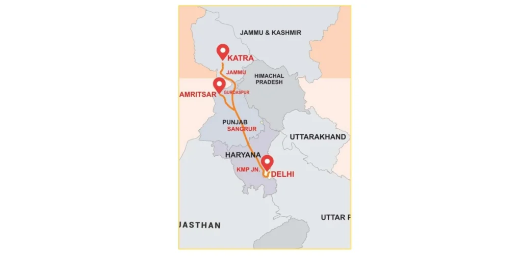
Delhi Katra Expressway Route Map is also changing the mode in which millions of pilgrims and travelers are traveling to the most holy places of North India. This is an ambitious construction with a 670-kilometer infrastructure wonder that will reduce travel between the holy town of Katra and Delhi, which has always been tedious at 14 hours, to a mere 6 hours.
The Delhi Katra Expressway Route Map was constructed under the Bharatmala Pariyojana project and cost an investment of Rs 38,905 crores, connecting a few of the religious sites of the country such as the Golden Temple in Amritsar and the Mata Vaishno Devi shrine in Katra. This expressway of the future will transform the connectivity in the state of Delhi, Haryana, Punjab, and Jammu and Kashmir and improve tourism, commerce, and development of the region.
Overview: Delhi to Katra Expressway
Delhi to Katra Expressway is one of the pioneering highways to be constructed with 670 kilometers along the route of Bahadurgarh close to Delhi to the pilgrimage town of Katra located in Jammu and Kashmir. This four-lane expressway is under the management of the National Highway Authority of India (NHAI) and can be extended to eight lanes, which will expand with the increase in traffic.
The express way reduces the Delhi- Amritsar trip that used to take 8 hours to only 4 hours and the Delhi- Katra trip that used to take 14 hours to only 6 hours. This is a mixed greenfield and brown field project that cuts across various districts uniting important religious hubs and establishing some form of economic potential never before seen in communities in its path.
Entry & Exit Points
The Delhi Katra Expressway Route Map has well-spaced entrance and exit points in four states to the map:
- Delhi: village of Jasaur Kheri (point of starting) by the border of Bahadurgarh.
- Haryana: Jhajgar (Jasaur Kheri), Rohtak (Hassangarh, Sampla-Kharkhoda), Sonipat (Lahkan Majra, Gohana), Jind (Jind, Assandh), Kaithal (Narwana-Kaithal)
- Punjab: Patiala (Kaithal-Khanauri), Sangrur (Roshanwala-Bhawanigarh), Malerkotla, Ludhiana (Raikot-Jodhan), Jalandhar (Nakodar-Phagwara), Kapurthala (Sultanpur Lodhi), Tarn Taran (Goindwal Sahib), Amritsar ( Amritsar bypass, Batala-Gurdaspur Road), Gurdaspur (Sri Hargobindpur
- Jammu and Kashmir: Jammu, Kathua, Katra (terminus at the end of the road).
Delhi Katra Expressway Route Map
There are two main stretches of the Delhi Katra Expressway Route Map:
- National Expressway 5 (NE-5): 397km green Field project linking Delhi-Nakodar-Gurdaspur.
- National Expressway 5A (NE-5A): 99 km road which connects Nakodar with Sri Guru Ram Dass Jee International Airport, Amritsar.
- Phase 2 Extension: Gurdaspur to Katra securing key pilgrimage routes.
The Delhi Katra Expressway Route Map cuts across such major cities as Bahadurgarh, Rohtak, Sonipat, Jind, Kaithal, Patiala, Sangrur, Malerkotla, Ludhiana, Jalandhar, Nakodar, Kapurthala, Tarn Taran, Amritsar, Gurdaspur, Pathankot, Kathua, and Katra. This is an extensive routing coverage coupled with connecting key religious destinations and as well the maximum connectivity to the regions.
Delhi Katra Expressway Cost
Total Project Cost: Rs 38,905 crore
Land Acquisition: Included in total budget
Construction: Multi-phase execution across 20 packages
Haryana Stretch Toll Rates (operational since November 2024):
- Light motor vehicles (Cars/Jeeps): Rs 240 one-way, Rs 360 round trip
- Light commercial vehicles: Rs 385 one-way, Rs 580 round trip
- Two-axle buses/trucks: Rs 805 one-way, Rs 1,210 round trip
- Three-axle commercial vehicles: Rs 880 one-way, Rs 1,320 round trip
Delhi Katra Expressway Phases
Katra Express way route in Delhi is being constructed in two huge stages:
- Phase 1 (Delhi-Nakodar-Gurdaspur): 397 km greenfield project broken down into 12 packages, 3 spur packages.
- Phase 2 (Gurdaspur-Katra): Greenfield and brownfield project of 99km, partitioned into 6 packages.
- Total Packages: 20 construction packages are given to different contractors.
- Status: Haryana stretch (135 km) was fully operational in November 2024.
- Anticipated Opening: Entire expressway by April 2026.
Delhi Katra Expressway Facilities
The amenities will be world-class for people traveling on the Delhi Katra Expressway Route Map:
- Safety Measures: Roadside fencing, animal protection fence, automatic vegetable garden, and plantation.
- Emergency Services: 24/7 trauma services, ambulances, and fire brigade services.
- Speed Limits: 120km/hr for light vehicles, 80km/hr for heavy vehicles.
- Refreshing points: Refrigerated bays, bus bays, truck parking points.
- Toll Infrastructure: Haryana has seven toll plazas extending individually.
- Traffic Control: There are traffic surveillance stations and speed lights every 100 meters.
- Health and Medical Services: Relief and health centers every now and then.
Route Villages & Town List
| State | District | Major Towns/Villages |
| Haryana | Jhajjar | Jasaur Kheri |
| Haryana | Rohtak | Hassangarh, Sampla, Kharkhoda |
| Haryana | Sonipat | Lahkan Majra, Gohana |
| Haryana | Jind | Jind, Assandh |
| Haryana | Kaithal | Narwana, Kaithal |
| Punjab | Patiala | Khanauri |
| Punjab | Sangrur | Roshanwala, Bhawanigarh |
| Punjab | Malerkotla | Malerkotla, Nabha |
| Punjab | Ludhiana | Raikot, Jodhan, Ludhiana |
| Punjab | Jalandhar | Nakodar, Phagwara |
| Punjab | Kapurthala | Sultanpur Lodhi, Kapurthala |
| Punjab | Tarn Taran | Tarn Taran, Goindwal Sahib, Khadoor Sahib |
| Punjab | Amritsar | Amritsar, Batala |
| Punjab | Gurdaspur | Sri Hargobindpur, Gurdaspur |
| Punjab | Pathankot | Bhoa, Sunder Chak |
| J&K | Kathua | Kathua |
| J&K | Jammu | Jammu |
| J&K | Reasi | Katra |
Travel Time & Distance Estimates
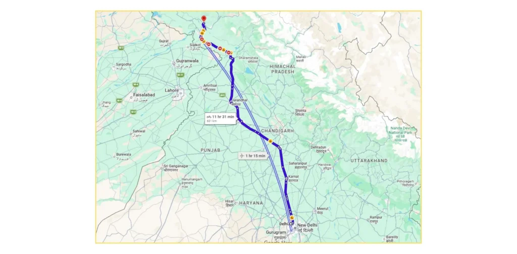
The Delhi Katra Expressway Route Map brings down the time of travel significantly:
Delhi to Amritsar:
- Current: 8 hours, 450+ km via NH-44
- New Path: 4 hours, 405km by expressway.
- Time Saved: 4 hours
Delhi to Katra:
- Current: 12-14 hours, 727 km
- New Route: 6-7 hours, 588 km
- Time Saved: 6-7 hours
- Sultanpur Lodhi to Delhi: It takes about 5 hours through the expressway.
Delhi to Jalandhar:
- This will take around 4.5 hours using the expressway.
- Amritsar to Katra: Slashed greatly and having direct connection.
Why This Expressway Matters
- Religious Tourism Boost: Delhi Katra Expressway Route Map provides a direct connection to major pilgrimage sites such as Golden Temple (Amritsar), Vaishno Devi (Katra), Sultanpur Lodhi, Goindwal Sahib, Khadoor Sahib, and Tarn Taran, making pilgrimages more accessible to millions of faith followers every year.
- Economic Development: The expressway promotes industrialization, logistic efficiency and commerce within the Punjab and Jammu states, which lowers transportation expenses and enhances access to markets by the local enterprises and agricultural goods.
- Real Estate Growth: In the Map of the Katra Expressway Route in Delhi, the property markets have recorded impressive growth of Amritsar (28.06% in 4 years), Malerkotla (27%), Ludhiana (18.57%), and Jalandhar (13.36), and this offers good investment prospects.
- Employment Generation: The construction, hospitality, food services, transportation, and tourism industries are putting thousands of people to work along the corridor, especially the communities surrounding religious sites such as Katra and Amritsar.
- Infrastructure Integration: The expressway is nebulously coupled with NE-5 and NE-5A which interconnects with the Amritsar International Airport and other highways thus covering the whole of the region and enhancing the greater development vision.
- Strategic Connectivity: The Delhi Katra Expressway Route Map enhances networks across the national highways, increases accessibility in the border areas, and furthermore, improves connectivity to strategic sensitized areas in Jammu and Kashmir, which add to national security goals.
Latest Status & Expected Opening
Current Operational Status:
- The Haryana stretch (135 km) will be completely operational from November 2024.
- Speed limit: 120km/hr speed limit on light vehicles, 80km/hr speed limit on heavy vehicles.
- There are seven toll plazas operating within the Haryana section.
Construction Progress:
- The greater number of packages were granted to contractors such as KCC Buildcon, CDS Infra Projects, Ceigall India, Evrascon-MKCIL JV and so on.
- Some parts of the Punjab section experiencing delays in land acquisition.
- Jammu and Kashmir division moving forward with packages to MEIL, Vishwa Samudra Engineering and APCO Infratech.
Expected Timeline:
- Full expressway completion: April 2026.
- The Prime Minister’s inspection planned to accelerate the project.
- NHAI is an active project in terms of its coordination with state authorities to address the outstanding land acquisition challenges.
Recent Developments:
- NHAI prepared a project of Rs 4,000 crore high classifying corridor between Delhi and Katra Western peripheral interchange and UER-2 to allow direct entry to Delhi.
- There is the longest cable-stayed bridge over Beas River measuring 1,300 meters long in infrastructure.
- State-of-the-art traffic management and safety systems are under construction.
Conclusion
The Delhi Katra Expressway Route Map is the giant stride that the development of infrastructure in India will take, the route that will provide India with the most connectivity it has ever had between the national capital and the spiritual center of North India. This Rs 38,905 crore mega-project will transform the religious tourism industry, boost the economy, and bring prosperity to four states by cutting the time taken to travel between Delhi and Katra down to a mere 6 hours.
The strategic orientation of the Delhi Katra Expressway Route Map has linked millions of people of religious faith to religious destinations such as Golden Temple and Vaishno Devi and has also provided new opportunities in terms of business, construction of real estate and job hunting. Since the Haryana stretch is already in operation and will reach full completion by the year April 2026, the Delhi Katra Expressway Route Map will remain a record of the Indian dream of world-class infrastructure that can be used not only to fulfill the spiritual calling but also the economic goals.
Also Read:
FAQs
How long is the overall length of the Delhi Katra Expressway?
The Delhi Katra Expressway is a 670 km (2500 ft) highway between Bahadurgarh near Delhi and Katra in Jammu and Kashmir, and is currently a 4-lane highway but can be expanded to 8 lanes.
How much time will you save traveling from Delhi to Katra?
The expressway saves about 6-8 hours of journey time and reduces the distance from 727 km to 588 km, bringing the travel time within that distance from 12-14 hours to 6-7 hours.
What will be the completion date of the Delhi Katra Expressway?
The full Delhi Katra Expressway will be fully operational by April 2026. The Haryana segment (135 km) has been in operation since November 2024.
What is the toll fee on the Delhi Katra expressway?
In Haryana, cars are charged Rs 240 one-way (Rs 360 round-trip), light commercial vehicles Rs 385 one-way (Rs 580 round-trip), and heavy vehicles Rs 805-880 one-way.
What religious places are linked to the Delhi Katra Expressway Route Map?
Expressway also links major pilgrimage sites such as Mata Vaishno Devi (Katra), the Golden Temple (Amritsar), Sultanpur Lodhi, Goindwal Sahib, Khadoor Sahib, and Tarn Taran, making them more accessible to devotees across the country.